Victory Square (Vancouver, British Columbia, Canada)

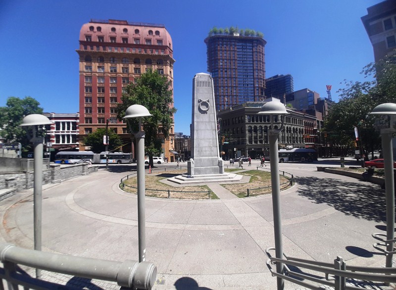
Victory Square and Cenotaph

Victory Square, bordered by West Hastings Street to the northeast, West Pender Street to the southwest, Cambie Street to the southeast, and Hamilton Street to the northwest, stands at the intersection of the old Granville town site (AKA Gastown) and the CPR Town site, which was the downtown-designated land grant obtained by the Canadian Pacific Railway (CPR) as part of the deal to locate the terminus and thereby found the city (the corner of Hastings and Hamilton is the northern tip of the CPR Townsite).

Check out “Gastown”

Hastings Street Side

The site of the Cenotaph is significant. In 1914, because of the strong royalist sentiment in the city, it was at tables at the foot of the old courthouse steps where enlistees signed up for the First World War.  The maple trees on the Pender Street side of the park are the oldest street trees in the city, planted in 1897.

Hamilton Street Side

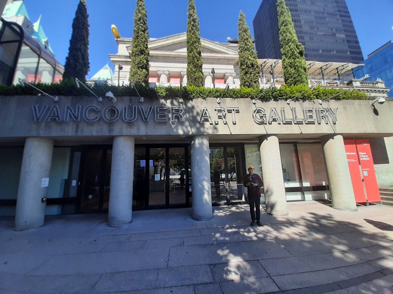
It was, at one time, the grounds of the city’s provincial courthouse, which was torn down in 1911–13 when the new Francis Rattenbury-designed courthouse along Georgia Street was opened (now the Vancouver Art Gallery). The term is also used to refer to the neighborhood immediately surrounding the square.

Check out “Vancouver Art Gallery

Pender Street Side

Here’s the historical timeline of the square:

  • On February 13, 1886, an area of 3,600 sq. m. (0.9acres) out of the1.9 sq. km. (480 acres) allotted to the CPR was held aside as “Government Square.” The southwest corner of Hamilton and Hastings Streets is where L. A. Hamilton drove the first survey stake to commence laying out the street system for the city.
  • On 27 April 1924, the Victory Square Cenotaph was unveiled by His Worship William Reid Owen (Mayor of Vancouver), in the presence of an assemblage of 25,000 persons; naval, military and civilian, and including the Old Contemptibles7th British Columbia29th Vancouver (its chaplain, Major Cecil C. Owen M.B.E., V.D., D.D., dedicated the cenotaph), 72nd Seaforths2nd Canadian Mounted Rifles47th New Westminster, and 102nd North British Columbian Battalions, CEF, and others.

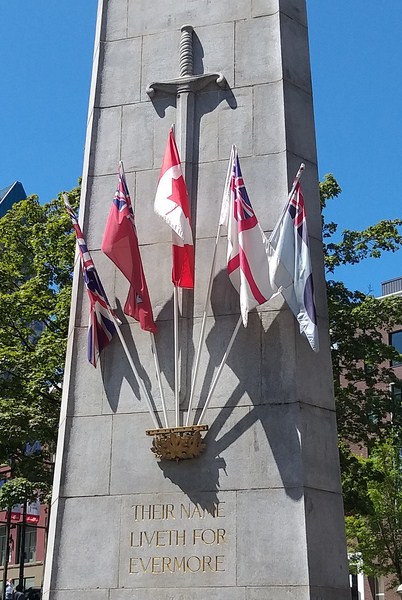
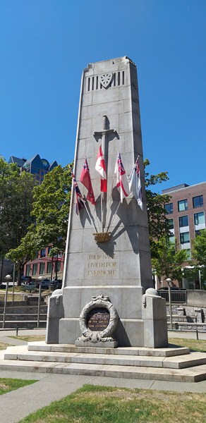
Pillar at Hastings Street side is decorated with a long sword and is engraved with the inscription “Their name liveth forevermore”and is kept continuously banked high with wreaths of flowers and adorned with national flags

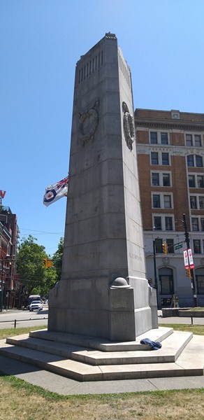
The approximately 9.1 m. (30 ft.) tall, triangular (its shape conforms to that of the square) Victory Square Cenotaph , the Vancouver war memorial, was designed thus by Maj. G.L. Thornton Sharp (architect, town planner and park commissioner).  The 24-man (12 represented the Canadian Club of Vancouver and 12 the Civic War Memorial Committee) Vancouver War Memorial Committee, under the chairmanship of pioneer F.W. Rounsefell, Esq. (with J.R.V. Dunlop, of the Canadian Club, as honorary secretary), were the public-spirited sponsors.

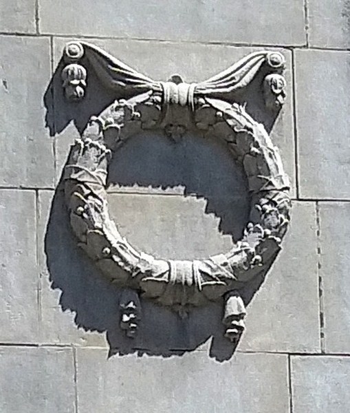
Wreath at the base of the Hastings Street side

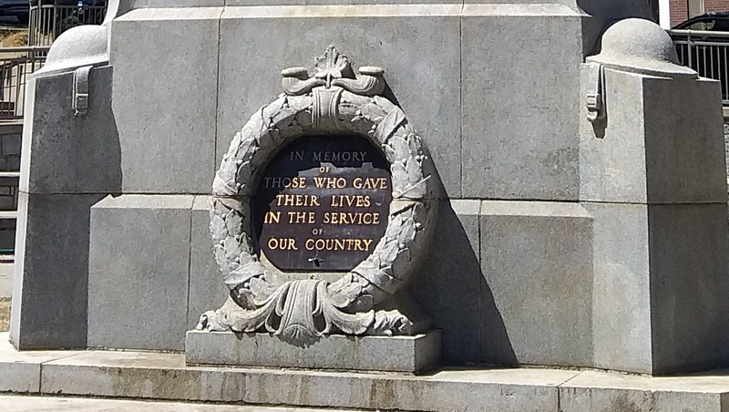
The word “cenotaph” (an empty tomb in memory of one buried elsewhere) is derived from the Greek word kenos (meaning “empty”) and taphos (meaning “tomb”).  The focus of the city’s annual Remembrance Day services, the Cenotaph lies at the foot of a gentle slope on the northern side of the square, on a plaza flanking Hastings Street. It is so placed that, when approached from the east, it appears in the distance centrally at the end of busy Hastings Street.

Wreath at Pender Street side

Made with gray Nelson Island granite (supplied by the Vancouver Granite Co., Ltd.), cost $10,666 and was erected by contractors Stewart who died from the effects of an accident whilst preparing the memorial) and Wylie. The pillar is engraved with suitable inscriptions and is kept continuously banked high with wreaths of flowers and adorned with national flags.

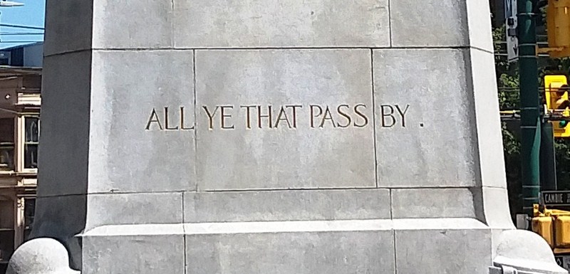
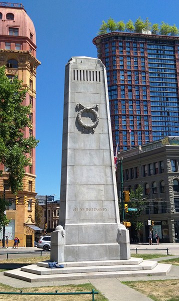
Inscription at Pender Street side that reads “All ye that pass by”

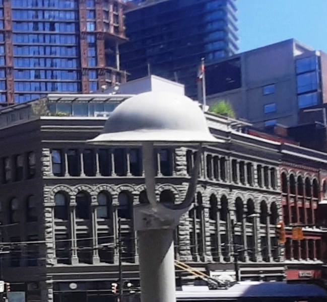
The stone ornamentations include one long sword and two wreaths (one of laurels, the other of poppies), both entwined with maple leaves.  The three corner buttresses are adorned by a stone replica of the steel helmet, as used in the war of 1914–1918.  The numerals “1914–1918,” at the base of the front, surrounds a larger wreath of laurels.

World War I helmet

A receptacle of three bronze maple leaves has slots that hold the staffs of the Union Jack, the Canadian Red Ensign, the Flag of Canada, the White Ensign, and RCAF Ensign, always flying, which are placed there by the Royal Canadian Legion and the Royal Commonwealth Ex-Services League, and renewed four times each year.
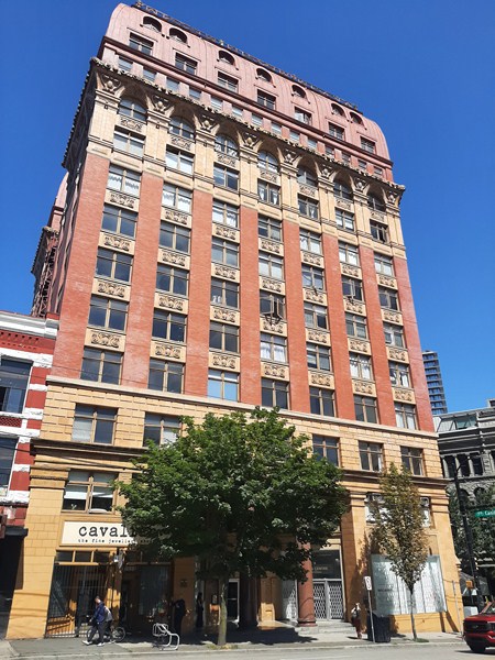
Sun Tower

One monument side faces busy Hastings Street (engraved inscription: “Their name liveth for evermore” and, within a stone wreath, “1914–1918″), the others Pender (engraved inscription: “All ye that pass by”) and Hamilton Streets (engraved inscription: “Is it nothing to you“). It is so placed that, when approached from the east, it appears in the distance centrally at the end of Hastings Street.

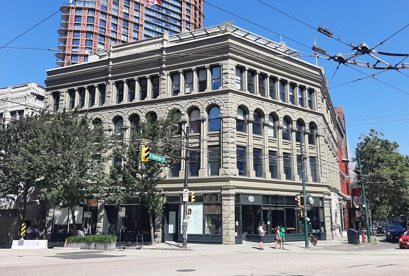
Flack Block (Copp Building)

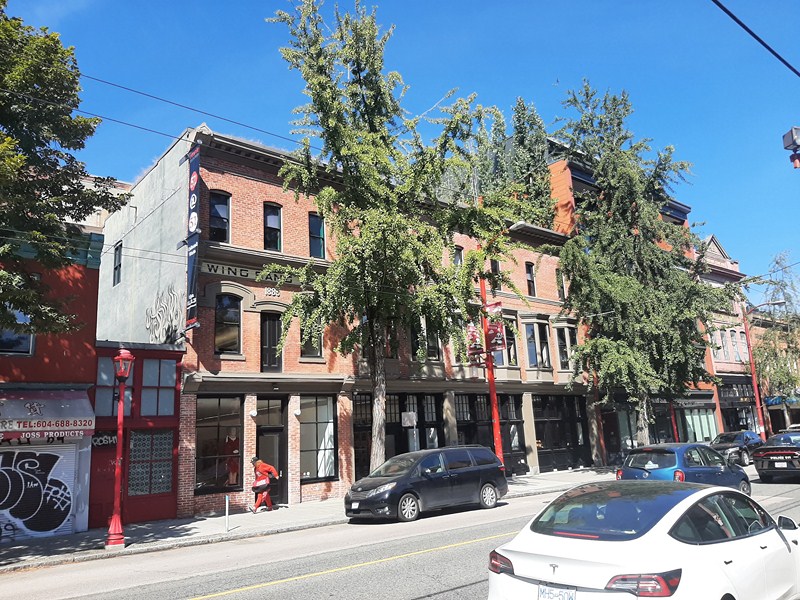
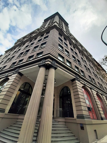
Several historic buildings adjacent to Victory Square include the 13-storey, 53-m. (175 ft.) high, Second Empire-style Dominion Building (completed in 1910); the four-storey, Romanesque Revival-style Flack Block (or Copp Building, completed in 1900) and the 17 storey, 82 m. (269 ft.) high, Beaux-Arts-style Sun Tower (completed in 1912).

Dominion Building

Victory Square: VancouverBritish ColumbiaCanada.

Fort San Antonio Abad (Manila)

Fort San Antonio Abad

Relatively unknown to many, Manila has another Spanish-era fort, aside from the well-known Fort Santiago, located south of Intramuros and this one is not easy to visit as it is located within the confines of the high-security Bangko Sentral ng Pilipinas (BSP)  Complex – the 1.2-hectare, trapezoid-shaped  and equally historic but hidden Fort San Antonio Abad.

Exploring the fort with our guides

Considering its current location, tightly sandwiched between the imposing main tower of the BSP and the old Manila Metropolitan Museum  Building (now transferred to its new home at Bonifacio Global City in Taguig City), the fort is understandably overlooked these days.

Check out “Metropolitan Museum of Manila

Stairs leading up to the ramparts

Visits to the fort are by appointment and my son Jandy and I had to arrange our visit in advance via email.  It was only upon approval of our request that we were allowed to proceed to the Bangko Sentral ng Pilipinas Complex.  Upon registering ourselves, we met up with our guides, Ms. Regyn Avena and Mr. Lauro E. de los Santos, Jr. who were to tour us around the fort.

The view of the South Wall from the East Bastion

Also known as Fort Malate or Fort San Antonio, this fortification was completed in 1584 and named in honor of its patron saintSaint Anthony the Abbot (feast day: January 17).   Like the walled city, the fort evolved into a variety of stone fortress popularized by renowned French military architect Sebastien Le Prestre de Vauban, with two signature bastions at the corners of the canted walls.

The canted South Wall

Though relatively small in size, it certainly occupies a significant place in the history of Manila as it played a role in three great conflicts – the Seven Years’ War,e vents prior and during the Philippine–American War and World War II.  Located in what was then a separate hamlet of Malate, the fort served as a rear protection for the Manila as well as to guard the Manila–Cavite route.

The West Bastion at the North Wall

The Spanish used the fort as a polvorista (“little fortress” or gunpowder magazine to safely store gunpowder) known as Fuerte de Polverina.  On September 26, 1762, during the Seven Years’ War, it was captured by British forces under Rear-Admiral Samuel Cornish and Brigadier-General William Draper when they invaded Manila. They transformed the fort into a garrison, setting up an artillery battery.  From here, the British forces launched their land offensive against the Spaniards defending Intramuros.

The exquisitely designed North Entrance

On March 26, 1764, upon the end of the British occupation of Manila, the fort was returned to Spanish control and rebuilt, again becoming a gunpowder storage facility. On August 13, 1898, after bombardment by U.S. warships during the sham Battle of Manila, the fort was captured and the first American flag hoisted by the First Battalion of the First Colorado Volunteer Regiment under the command of Lt.-Col. Henry Bayard McCoy.

The grassy courtyard. On the left are the square embrasures

Also, during the Philippine–American War, U.S. military authorities used the prison to carry out multiple executions by hanging. Harry Cline, an American civilian under the employment of the United States Army, was the first American to be executed by U.S. authorities after he shot, with a revolver, four small Filipino boys from Parañaque gathering grass, wounding three and killing the fourth (Agaton Rivera) on April 8, 1901. Cline was tried by an American military court, found guilty of murder and three counts of assault with intent to kill, and sentenced to death by hanging which was carried out  on September 20, 1901.

The fort ramparts

During World War II, Fort San Antonio Abad was seized by occupying Japanese  troops and it was used as a bunker, with a cannon installed. During the Liberation of Manila, the fort suffered considerable damage.  After World War II, the very young Offshore Patrol, with the Manila Naval Station (MNS) as its main support unit, set up its headquarters at the fort. They vacated the place in 1965.

The now unused well with windlass

On June 1974, coinciding with the establishment of the new main office complex of the BSP, the restoration of the fort was again started (the first restoration was at the beginning of the 19th century) by Architect Carlos E. Da Silva, during the term of former Bangko Sentral ng Pilipinas Gov. Gregorio S. Licaros, and completed in 1976.

1976 Restoration Plaque

This battle-weary and proud structure is now a beautiful little park and events place with paved walkways and street lamps. Where guards once stood, there are now roaming gardeners keeping the manicured garden trim. Within the garden is a now unused well with a windlass for raising water.

National Historical Treasure plaque

In 2018, together with Intramuros (collectively known as the “Fortifications of Manila”), the fort was named a National Cultural Treasure (NCT), for their architectural, historical, scientific and archaeological significance, by the National Museum of the Philippines. Both forts were essential parts of the defense of Spanish Colonial Manila and scientifically important in terms of military and structural engineering. The NCT marker is now installed there and in Plaza Roma in Intramuros.

The unadorned south entrance. In my opinion, this entrance seems like a recent addition as there as its walls show no signs of weathering

At the fort’s south entrance, two historical plaques (the 1976 renovation plaque and the NCT plaque) are mounted.  A Historical Research and Markers Committee (now the National Historical Commission of the Philippines) marker, installed  in 1937, is mounted on the wall to the right of this entrance, is topped by a semicircular arch niche, flanked by Doric columns, with an antique wooden statue of St. Anthony Abbot within.

Niche with statue of St. Anthony Abbot

In turn, the niche is framed by a decorative moldings ending in scrolls. The original segmental arched main entrance of the fort, with its quaint iron gate, faces north.  This latter entrance is decorated with a bas-relief of the traditional Spanish coat of arms of Leon (the lion) and Castille (the castle) and topped by finials.

Bas-relief bearing the Spanish coat of arms at the North Entrance

The fort can be quickly explored in less than half an hour. At the lower level of the fort are a series of square embrasures, openings in fort’s walls where cannons can be fired.  These openings, flared outward to enlarge their field of fire, once faced the sea but are now facing the back of the museum.

One of the fort’s embrasures

You can walk around the entire wall perimeter via very narrow, 2-foot wide ramparts which can be reached via stone steps. Standing on either side of the fort, on arrowhead-shaped bulwarks (East and West), are two large, sea-facing naval guns which were damaged when the American Air Force bombed the fort during the 1945 Liberation of Manila in World War II.

William Armstrong gun at the East Bastion

Cast by Sir William Armstrong & Co. (England), these two 19th century, rifled breech-loading guns, weighing 20,238 and 20,220 pounds respectively, had a bore of 8 inches.  The original gun carriages are now gone (probably destroyed during the bombing or have rotted away) and have been replaced by concrete supports.

Pockmarked William Armstrong gun at West Bastion

AUTHOR’S COMMENTS:

After our visit to the fort, I can’t help but notice the differences between the plain looking south entrance and the exuberantly decorated north entrance.  Plus, I also can’t help but notice the seemingly misplaced bas-re;ief, with its statued niche, to the right of the south entrance.  This has got me thinking.

Could the south entrance have been originally located just below this bas-relief? It would make sense as statues of saints in niches or in bas-reliefs are usually placed above the entrances of churches and forts (even Fort Santiago has a bas relief of St. James the Moor Slayer, its patron saint, above its main entrance) to watch over those who enter.  Probably the lower and narrower entrance (suitable for wagons), with its pilasters, must have been walled up and a new, simple but higher and wider square opening was created, during the American era, a few meters beside it, possibly to allow tall and wide-bodied vehicles such as trucks to pass through.  I wonder ……..

For me, this makes sense…..

Fort San Antonio Abad: Banko Sentral ng Pilipinas Complex, Malate, Manila 1004.  E-mail corporateaffairs@bsp.gov.ph (to arrange for a visit).

Museo ng Sapatos (Marikina City, Metro Manila)

Museo ng Sapatos (Shoe Museum)

The Museo ng Sapatos (Shoe Museum), formerly known as the Footwear Museum of Marikina, is housed in an old stone building (bigasang bayan) built in 1880s by Dona Teresa de la Paz of the affluent Tuason family to store palay.   During the Philippine Revolution, it served as an armory of the Guardia Civil and, during the Philippine–American War, the building was used as a detention center.

Museum entrance

During the American era, it was then used as a motor pool and, during the Japanese Occupation, it served as a detention center for suspected guerillas.  After World War II, the structure was repurposed as a rice mill by the Tuason family but was later abandoned.

Museum interior

In 1998, Mayor Bayani F. Fernando conceived the idea to open a museum dedicated to Marikina‘s 110-year old shoe industry and, in 2000, he had it renovated and converted into a museum.

Column wrapped with shoe lasts

Opened as Marikina Footwear Museum on February 16, 2001, it aims to showcase the shoes worn by prominent figures and personalities in the Philippine history and to trace the history of the shoe industry.  Imelda R. Marcos herself led the museum’s opening.  When Typhoon Ondoy struck in 2009, water reached 4 ft. high inside the museum and many shoes were damaged.

Imelda Marcos Shoes Gallery. At the end are the Filipiniana dress of Imelda Marcos and the barong tagalog of Pres. Ferdinand E. Marcos

At the center of the hall is a column of old wooden shoe lasts. A stairway leads up to the mezzanine where 749 pairs (as of 2020) of size eight-and-a-half footwear (shoes, downy boudoir slippers, slick knee-length boots, open-toed linen espadrilles, alligator pumps, etc.)  of former First Lady Imelda R. Marcos, an active promoter of Marikina’s shoe industry, are displayed, occupying one long wall of cabinets.

Shoes of Pres. Ferdinand E. Marcos

Shoes of Pres. Manuel A. Roxas

Aside from shoes from local designers (she was gifted an average of 10 pairs a week), they include handcrafted designer pieces from brands such as Charles Jourdan, Beltrami, Christian Dior, Gucci and Oleg Cassini.  Also on display are a Filipiniana dress worn by her and a barong tagalog worn by the late Pres. Ferdinand E. Marcos.

Shoes of Pres. Gloria Macapagal-Arroyo

Shoes of Pres. Fidel V. Ramos

Seized by the Presidential Commission on Good Government, they were formerly on display, for six years, at the Malacañang Palace Museum (now the Malacanang Museum and Library) during Corazon Aquino‘s presidential term.

Check out “Malacanang Museum and Library

Celebrity Shoes

It was later placed in storage at the beginning of Fidel V. Ramos‘s presidency.  In 1996, a portion of Marcos’ shoe collection was requested to be transferred to the Marikina city government led by Mayor Bayani Fernando. Marcos did not object to the request in 1998.

Shoes of former Marikina City Mayor Bayani Fernando

Bowling shoes of six-time World bowling champion Paeng Nepomuceno

Also on display are shoes worn by the late President Ferdinand E. Marcos plus shoes donated by the late President Fidel V. Ramos, President Joseph Estrada (a size 10) and President Gloria Macapagal-Arroyo, and shoes donated by other politicians (Sen. Loren Legarda, Cong. Jose de Venecia, Bongbong Marcos, etc.) including a pair of shoes from Senator Miriam Defensor Santiago which she wore during the 1992 Presidential Campaign and during her visit to local shoe manufacturers in Marikina.

Evolution of Shoes

Circa 1930s to 1970s

There are also shoes from showbiz figures (Agot IsidroDolphy, Fernando Poe Jr., Christine Reyes, April Boy Regino, Angel Aquino, John Arcilla, Rosa Rosal, etc.) , athletes (Paeng Nepomuceno, Eugene Torre, etc.), beauty queens (Venus Raj, etc.) and other well-known personalities (Lisa Macuja-Elizalde, Jaime Cardinal Sin, First Lady Amelita Ramos, etc.).

Circa 1980s to 2000s

Circa 2001 to the Present

Aside from celebrity shoes, there is a display about footwear through the ages. Highlights include kinds of shoes icemen would have worn back in 3300 BC, Dutch clogs, Viking boots, Roman sandals and Indian moccasins.  Also on display are the products that made Marikina as the Shoe Capital of the Philippines.

Singer sewing machine

Men’s and Ladies’ Shoe Stands and Manual Delaster

On another corner are award-winning shoes, mostly fantasy footwear, from the city’s annual design competition.

A 3-foot high leather shoe

Also on display are actual cobbler’s tools, a sewing machine, shoe lasts, shoe components, men’s and ladies’ shoe stands and a manual delaster.  There’s also a huge, 3 ft. high leather shoe.

Shoe Components

Cobbler’s tools

On the sidewalk surrounding the Shoe Museum is the Shoe-perstar Alley, a walk-of-fame inaugurated on November 13, 2012 (Sapatos Festival).

Angel Locsin and Joel Lamangan

It features 49 famous personalities from different careers like politics, sports, arts, entertainment, music, philanthropy, business, news and current affairs, fashion and beauty, and religion who have greatly contributed to the upliftment of the shoe industry in Marikina.  Their names are placed on 60cm. x 60cm. tiles that have a 16cm. x 16cm. shoe design made of brass.

Monique Wilson and Brian Tenorio

Also outside the Shoe Museum is a century-old acacia tree, one of two Heritage Trees in Marikina which are enduring witnesses to city’s history, particularly the growth and struggles of its footwear industry. Now laying on its side, the trunk blocking J.P. Rizal Street and half of the roots unearthed and exposed, it was uprooted by a tornado spawned by Typhoon Ompong on September 14, 2018. First aid methods and bonsai techniques had been used to revive this acacia and it is now considered a symbol of the community’s own survival and resilience.

The still resilient Heritage Tree

Museo ng Sapatos:  J.P. Rizal St., San Roque, Marikina City (50 m. from the Sentrong Pangkultura ng Marikina), Metro Manila.  Open daily, 7:30 AM to 4:30 PM.  Admission: Php50.  Tel: (632) 696-6516.E-mail: marikinatourism@gmail.com.

How to Get There: take the LRT-2 to Santolan (its last stop) and then take a San Mateo-bound jeepney to City Hallon Central Shoe Ave.  From there, it is a short walk to the museum.

Sentrong Pangkultura ng Marikina (Metro Manila)

Sentrong Pangkultura ng Marikina

The over two century old Sentrong Pangkultura ng Marikina, formerly the old Kapitan Moy building, was constructed in 1780 by Don Jose Guevarra whose family owns “Asyenda Tyason.” Andres Bonifacio of the Katipunan once visited the place and, in 1901, the American soldiers made it a camp.

National Historical Commission plaque installed in 1970

Once owned by Don Laureano “Kapitan Moy” Guevarra (July 4, 1851 – December 30, 1891), recognized as the father of the shoe industry in the Philippines (he also served as capitan municipal in the former municipality), the first pair of shoes in Marikina was designed and made in 1887.

Don Laureano “Kapitan Moy” Guevarra

Doña Teresa dela Paz, a haciendera, then bought the house of Kapitan Moy to serve the needs of the marginal sector of the community, converting it into a home of needy residents of Marikina. Doña Teresa then presented the dwelling to his brother-in-law Don Jose Espiritu who transformed it into a primary school from 1907 to 1955.

Interior

When the Americans occupied the Philippines, the building also served as the house of the American tribunal. From 1942 to 1945, when the Japanese came over, it became the Japanese Imperial Army’s headquarters.

In 1968, it was also declared as a National Shrine by the municipal council and NHCP.  On April 16, 1970, the building was commemorated with a cast-iron plaque marker and listed as a Historic Site and Structure by the National Historical Commission of the Philippines (NHCP) for being the Unang Pagawaan ng Sapatos sa Marikina or the First Shoe Workshop in Marikina.

Galeria

It is also recognized as a Cultural Property of the Philippines by the National Commission on Culture and the Arts, National Historical Commission of the Philippines, and the National Museum of the Philippines.

Cafe Kapitan Restaurant

On April 16, 1986, the building was declared as the Sentrong Pangkultura ng Marikina (Cultural Center of Marikina) by the Marikina local government. On September 14, 2018, the building was damaged by a tornado , a day before Typhoon Mangkhut (Ompong) struck Cagayan Valley, disrupting the wedding reception held at the building.

Cafe Kapitan Restaurant

Inside this building can be found Doll Museum, Marikina City’s museum, a diorama showcasing the events and history of Marikina. It also houses two restaurants (Café Kapitan Restaurant and Kusina ni Kambal).

Exterior stairs leading to the second floor

At the Café Kapitan Restaurant is an old well which serves as a décor and a wishing well to customers at the ground floor and is also a venue for seminars, conventions and other events.

Bulwagang Bayani

The fully airconditioned Bulwagang Bayani, located on the second floor, can accommodate 400 to 450 guests. The Plaza Kapitan may also be rented for different occasions.

The author at Sentrong Pangkultura ng Marikina

Sentrong Pangkultura ng Marikina: 323 J.P. Rizal St.,1800  Marikina City, Metro Manila.

Quezon Heritage House (Quezon City, Metro Manila))

Quezon Heritage House

The Quezon Heritage House, a historic house museum within the grounds of the Quezon Memorial Circle, is situated across the Quezon City Hall. It serves as a museum focusing on the personal life of former President Manuel Quezon, complementing the nearby Museo ni Manuel L. Quezon at the base of the Quezon Memorial Shrine which focuses on the former president’s political career.

Check out “Quezon Memorial Circle,” “Quezon Memorial Shrine” and “Museo ni Manuel L. Quezon”

Built in 1927, the house was originally located at 45 Gilmore Street in Hacienda Magdalena (now New Manila). The Quezons moved to the house in 1927 when it was offered to them after Manuel Quezon contracted tuberculosis as the Santol Sanitarium  was just nearby.  The Quezons acquired the house on installment and managed to acquire three adjacent properties near the house.

Until they were forced to flee to Corregidor in 1941 during the World War II, the house was used as a weekend home by the Quezons.  After Manuel Quezon died in 1944, his family moved back to the house the next year, making it again as their family weekend house.  Later, it was occupied by the family of Maria Zeneida Quezon-Avanceña but, due to health reasons, she later moved out of the house to reside in Alabang.

During the administration of then city mayor Feliciano Belmonte Jr., plans to preserve the house were made. Belmonte approached the National Historical Commission of the Philippines and had talks on the city government’s prospects of acquiring the house, as well as the registration of the building as a heritage site.  However, the house did not meet all requirements for the designation.

The house was sold in 2012 and was about to be razed, when Mayor Herbert M. Bautista (born May 12, 1968) had the house disassembled and reconstructed in Quezon Memorial Circle. In April 2013, a new foundation was laid for the house and then the house in Gilmore was disassembled. About 60% of the parts of the house were removed with care and used for restoration. In June of the same year, the disassembling process was finished.

The total cost for the relocation was ₱10 million. The Quezon family also donated some furniture and fixtures for the house. In 2015, the Quezon Heritage House was designated as a Local Heritage Site of Quezon City by virtue of Ordinance No. SP-2428 passed by the Quezon City Council.

The two-storey Quezon Heritage House, painted in beige and white, did not follow strictly the Neo-Classical style theme as it underwent, in the span of more than 50 years, several modifications by the Quezon family.   Serving as the main entrance of the house are glass doors etched with bamboo with iron-wrought leaves, one of the non-Neo-Classical features of the heritage house.

Social Hall

An adjacent, single-storey rectangular social hall, present in the Quezon house complex, has round columns and features Fu Dog sculptures and two Caryatids as part of the support. A rectangular pool, between the social hall and the house building, was converted into a fountain when the building was transferred to the Quezon Memorial Circle.

The house’s living room, on the ground floor, was used by former First Lady Aurora Quezon as her office where she was establishing the Philippine National Red Cross.  Also on the same floor is a room used by Aurora as her age advances.   During the time the Quezon-Avanceñas were occupying the house, it was used as a guest room. A kitchen, each for the first and second floor, was also constructed.

The second floor, the primary attraction of the museum, is where the two bedrooms, with the original narra beds, of former president Quezon and his wife (the couple had separate rooms due to Manuel Quezon’s illness) are situated.  Both are linked by a comfort room. The original spiral staircase was retained upon its relocation to its current place. The cabinets and mirrors, doors, grills and some stained glass panels are all original.

Aside from featuring the interiors, furnishing and properties of the Quezón family, also on display are artworks by Guillermo Estrella Tolentino (1890 -1976), Miguel Geronimo Galvez (1912-1989), Loreto T. Racuya (born 1940), German M. Icarangal (1914-1984), R.F. Tapino, P. Żółcią, and E.P. Lim.

Beside the Quezon Heritage House is the Philippine-Israel Friendship Park, inaugurated in 2017, which commemorates Pres. Quezón’s opening the Philippines to Jewish refugees from the Nazi  persecution of World War II.

Quezon Heritage House: Quezon Memorial Shrine, Quezon Memorial Circle, Elliptical Road, Diliman,  Quezon CityMetro Manila.  Admission is free.  Coordinates: 14°38′58.4″N 121°03′01.1″E

Barcelona Ruins Park (Sorsogon)

Barcelona Ruins Park

Part of the Sorsogon Countryside Tour

Across the road from the Church of St. Joseph the Worker, built along the shoreline of the Pacific Ocean, is the Barcelona Ruins Park.  Located here are the ruins of a school building (for children of wealthy “illustrados”), at te southeastern tip of the park, and the prominent, two storey “La Presidencia,” at the northwestern tip of the park.

Check out “Church of St. Joseph the Worker

Ruins of the Presidencia

Also within the park is a modern, solar-powered lighthouse (erected in 1994 through a grant from the British government) and a “Barcelona SORSOGON” sign, a trend among towns, cities and landmarks this decade. A great place to relax and view the bay for the locals, at some of its areas, there’s free WiFi connection.

Built in 1874, the nearly century and a half La Presidencia was the seat of the Spanish Colonial-era gobernadorcillo (“little governor”). Massive in size, this structure also doubled as a watchtower and fortress against Moro pirate attack.

In the event of a retreat from the attacks, there was originally an underground tunnel leading to the aforementioned church but was closed to prevent thieves from accessing religious relics in the church.

The solar-powered lighthouse

During the Japanese Occupation in World War II, it was used by the Japanese as a garrison.  After the war, it was again used as the seat of the municipal government.

The park sea wall

However, a series of typhoons, ripped the building’s roof and the building was abandoned.  Today, it is a historical landmark of the town.

AUTHOR’S COMMENTS

The feeling of mystery makes vegetation in ruins more appealing and enjoyable to visitors but it is a known fact that vegetation causes physical damage and deterioration to standing structures in archaeological sites and monuments thereby increasing the risk of collapse and danger to those underneath.  I suggest removal of such greenery.

A new Spanish-inspired, two-storey municipal hall building was built in 2020.

The new Barcelona Municipal Hall

Barcelona Ruins Park: Poblacion Central, Barcelona, Sorsogon.

How to Get There: Barcelona is located 548.5 kms. (an 11.25-hour drive) from Manila and 27 kms. southeast of Sorsogon City.  From Sorsogon City, take a jeepney to Gubat then transfer to another jeepney at Barcelona.

Sorsogon Provincial Tourism Culture and Arts Office: Ground Floor, Capitol Building, 4700 Sorsogon City. Mobile number: (0968) 624-6279. E-mail: tourism@sorsogon.gov.ph.  Facebook: www.facebook.com/sorsogonprovincialtourismoffice.

Barcelona Municipal Tourism Office: mobile numbers (0908) 927-6481 and (0917) 348-7084.

Ur Place Travel & Tours: OLV Pangpang, Sorsogon City, Sorsogon.  Mobile number (Viber): (0927) 950-3927 (Ms. Annie Gueb).  Facebook: www.facebook.com/urplacetravel.

Astillero de Panlatuan Ruins (Pilar Sorsogon)

Part of Sorsogon Countryside Tour

A few minutes hike from Casa Almei Beach Resort are the Ruins of the Astillero de Panlatuan.  Astilleros are Spanish-era shipyards used for construction and repair of the galleons that plied the Manila-Acapulco Galleon trade. The towns of Donsol and Pilar, both sheltered from typhoons and having extensive coasts dotted by bays, coves and major rivers that are navigable, were the location of several shipyards. An extensive mangrove surrounds them, making it a safe haven for boats and people.

Astillero de Panlatuan Ruins

The astillero at Donsol (probably used as a construction, repair and smelting site) was established at the mouth of a river while the astillero at Pilar was established on a cove. When the important astillero on Bagatao Island in Magallanes was destroyed by Moro pirates, it was transferred to Panlatuan Bay after the Galleon Trade ended in 1650.

A portion of the fence built with cobble stones, with imported broken glass on the top for added protection

The revolution in Sorsogon was ignited  by the abuse and exploitation of the Panlatuan shipyard workers by their Spanish masters.  On August 5, 1898, desperate workers of the astillero rose in arms and raided the homes of four Spaniards residing in the barrio, slaying them with machetes.

Another stone structure on the site

The two astilleros of Pilar are separated by bodies of waters. The Binanuahan Astillero (probably the administrative site), at the Pilar Peninsula, is more inland while the Panlatuan Astillero (probably the construction and smelting site), located on a cove, is nearer the sea.  The deep waters, two rivers, an extensive mangrove, a vast flatland and a hill of the latter made it a favorable choice for an astillero.

The Panlatuan astillero has the best preserved features of the three.  Remains of large (approximately 30-40 cm. in diameter), equidistantly buried wooden posts, seen during low tide (only 30 cms. Can be seen), are associated with the presence of a pier and are arranged either parallel or perpendicular to each other.

Travel agents listen as our guide narrates the history of the site

The remains of a big gate, ruins of watchtowers and a warehouse were also documented during archaeological surveys and excavations done in the 1990s. Two old deep wells on the site, built with adobe tuff, are still being used by the owners.

One of several deep water wells on the site

The stone structures had thick walls made with riverine stones, adobe tuff and lime mortar; a roof with earthenware tiles and big windows and door frames. The watchtower used riverine cobble stones while the fence enclosing the astillero used cobble stones with imported broken glass on the top for added protection.

A ceramic shard recovered from the site

Corroded iron nails, chain rings, bronze sheathing nails, iron tools, a porthole window, Chinese, European and local ceramic shards (I was given one recovered on the site), brick tiles and Spanish coins were recovered on this site. A large slag concentration, pointing to smelting activities in the past, was also found on the northeastern side.

AUTHOR’S COMMENTS

Since the Panlatuan astillero was part of a series of events that resulted in the rapid spread of revolutionary activities in Sorsogon it, in my opinion, deserves to be declared a National Historical Site by the National Historical Commission of the Philippines, with a historical plaque installed.  The site should also be rehabilitated and restored.

Astillero de Panlatuan Ruins: Panlatunan, 4714 Pilar, Sorsogon.

How to Get There: Pilar is located 495.2 kms. (a 12-hr. drive  via Pan Philippine Highway/AH26) from Manila and 57.7 kms. (a 1-hr. drive via Central Nautical Highway and Pan-Philippine Highway/AH26) from Sorsogon City.

Sorsogon Provincial Tourism Culture and Arts Office: Ground Floor, Capitol Building, 4700 Sorsogon City. Mobile number: (0968) 624-6279. E-mail: tourism@sorsogon.gov.ph.  Facebook: www.facebook.com/sorsogonprovincialtourismoffice.

Pilar Municipal Tourism Office: E-mail: pilarsor.tourism@gmail.com.  Mobile number: (0948) 955-7727.

Ur Place Travel & Tours: OLV Pangpang, Sorsogon City, Sorsogon.  Mobile number (Viber): (0927) 950-3927 (Ms. Annie Gueb).  Facebook: www.facebook.com/urplacetravel.

Vancouver Chinatown (British Columbia, Canada)

Vancouver Chinatown, Canada’s largest

On our 35th day in Vancouver, Jandy and I returned (the first was in August 10 when we visited the Dr. Sun Yat Sen Classical Chinese Garden and Park) to Vancouver Chinatown, Canada‘s largest Chinatown, which is home to important cultural heritage assets and many community organizations with deep historical roots in Vancouver and Canada.

Check out “Dr. Sun Yat Sen Classical Chinese Garden and Park

Across 130 years of change, the district, one of the most significant urban heritage sites in Canada, has experienced recent decline as newer members of Vancouver’s Chinese community dispersed to other parts of the metropolitan area.  However, it still maintains a strong community and cultural identity.

Jandy, Kyle and Grace at Vancouver Chinatown

Centered around Pender Street, this popular tourist attraction is one of the largest historic Chinatowns in North America.  Its approximate borders, as designated by the City of Vancouver, are the alley between Pender and Hastings Streets, Georgia Street, Gore Avenue and Taylor Street.  Unofficially, the area extends well into the rest of the Downtown Eastside.

East Pender Street

The principal areas of commercial activity are Main, Pender and Keefer Streets. Chinatown is surrounded by Gastown to the north, the Downtown financial and central business districts to the west, the Georgia Viaduct and the False Creek inlet to the south, the Downtown Eastside and the remnant of old Japantown to the northeast, and the residential neighborhood of Strathcona to the southeast.

Due to the large ethnic Chinese presence in Vancouver (especially represented by mostly Cantonese-speaking multi-generation Chinese Canadians and first-generation immigrants from Hong Kong), the city has been referred to as “Hongcouver.”  In recent years, however, most immigration has been Mandarin-speaking residents from Mainland China.

In 2011, the neighborhood was designated a National Historic Site of Canada.  Many of the substantial buildings here were built in a distinct “Chinatown architectural style,” with vertical proportions, four storeys (with one or more of the upper floors featuring recessed balconies and others fully glazed) and with a classical metal cornice.

Vancouver Chinatown Millennium Gate

Our tour of Chinatown began when we entered the Chinatown Millennium Gate which straddles Pender Street, near the intersection with Taylor Street.  It marks the western boundary of Chinatown.  Designed by local architect Joe Y. Wai (1940–2017), whose work and contribution can be seen throughout Chinatown.

One of two guardian lions at the gate

The gate was approved on September 20, 2001 and erected in 2002 at the same site as a temporary wooden arch built to celebrate the 1901 royal tour by the Duke and Duchess of Cornwall and York. The Millennium Gate recalls gates you may find at the entrances to villages in southern China. On the eastern face are Chinese characters which read “Remember the past and look forward to the future.”

Past the gate, at the right, is the Sam Kee Building (8 West Pender Street) credited, by the Guiness Book of World Records, as “The world’s shallowest (not the narrowest) freestanding building in the world.” The building’s namesake, the Sam Kee Company, was run by successful business leader Chang Toy, one of the wealthier merchants in turn-of-the-20th-century Chinatown.

Sam Kee Building

One of the largest Chinese merchant firms in Vancouver, the company, established in 1888, manufactured charcoal, operated a herring saltery in Nanaimo and contracted Chinese labor to various industries. It also imported and exported food products to and from China, served as agents for the Blue Funnel Steamship Line and possessed sizable real estate holdings throughout Greater Vancouver.

The narrow 1.8 m.(6 ft.) side of the building

In 1903, Chang Toy bought the standard-sized lot for the building. The lot was the previous home to Shanghai Alley, an early Vancouver red light district which collaboratively hosted 105 brothels with Canton Alley. However, in 1912 the city widened Pender Street, expropriating (which Toy’s lawyers negotiated a fair market price) all but 6 ft. of the Pender Street side of the lot. In 1913, he hired architects Bryan and Gillam to design this narrow steel-framed free-standing building for offices, business and bath houses on the remaining narrow 6-ft. strip, costing just $8,000 to erect.

View of the room at the narrow side of the building

To maximize use of the property, the building basement (such basements in Vancouver were once common and zoned as “areaways”), much wider than the rest of the building, extended under the sidewalk and housed public baths. On the ground floor were shops while offices were located above. In the 1980s, the building was rehabilitated for Jack Chow and completed in 1986. Designed by Soren Rasmussen Architect, the glass prisms that were set in a tight grid across the sidewalk to light the basement, were replaced with modern glass.

Chinatown Heritage Alley (Shanghai Alley)

At the end of Shanghai Alley (or Chinatown Heritage Alley), near West Pender Street, is the Allan Yap Circle.  Here, hangs a replica Western Han Dynasty bell, a gift to Vancouver from sister city Guangzhou and a symbol of the historic connection between the two cities and their urban settlements, which was dedicated on June 26, 2001.

Allan Yap Circle

Also on this corner is S.U.C.C.E.S.S., created in Vancouver in 1973 to assist new Canadians of Chinese descent to overcome language and cultural barriers. The organization is now one of BC’s largest social services organizations with locations also in Taiwan and Korea.

Across the Sam Kee Building is the Chinese Freemasons Building (3-9 West Pender Street).  Originally the site of a Methodist church (in 1888, the first to minister to the Chinese community in Vancouver) from 1889 until 1907 when the Chee Kung Tong (a traditional Chinese fraternal organization which provided welfare assistance to the earliest Chinese immigrants during the Fraser Canyon Gold Rush of 1858) constructed the current building. In 1920, the organization adopted the English name the Chinese Freemasons in order to forge links with European Freemasonry.

Chinese Freemasons Building

Like many overseas organizations, it was deeply involved in Chinese politics. The building was even mortgaged to help fund Dr. Sun Yat-Sen’s (whose efforts the Freemasons supported to bring democracy to China) 1911 rebellion. The building also served as the original home of the successful business, Modernize Tailors, one of many tailors (a profession available to Chinese Canadians in an era of employment restrictions in the area). After a fire in 1975, the building was repaired and, in the early 2000s, a careful restoration was completed by Joe Wai for the Wong family.

Facing the Freemason Building is the two-storey, brick Chinese Times Building (1 East Pender Street).  Commissioned by successful businessman and community leader Yip Sang, it was designed in 1901 by architect W.T. Whiteway. From the 1930s to 1990s, the building was home to The Chinese Times, an important source for local and Chinese political news, managed by the Chinese Freemasons.

Chinese Times Building

When the newspaper moved in, a mezzanine floor was added to accommodate the typesetters who used the 5,000 different Chinese characters to create each edition. Since the typesetters sat all day, the ceiling is only 6 ft. high.  Through the ground floor windows, the printing presses could be viewed and men gathered to read the paper pasted to the Carrall Street wall.

Around the corner, from Sam Kee Building, is the Lim Sai Hor (Kow Mok) Benevolent Association Building (525-531 Carrall Street).  The earliest surviving association building, it was constructed in 1903 for the Chinese Empire Reform Association (focusing to bring about political reform in China, its members included Chang Toy, Yip Sang and Alexander Won Cumyow, the first person of Chinese descent born in Canada), the most influential association in Chinatown at the time. At its height (it faded with the fall of the Qing Empire and the emergence of the Dr. Sun Yat-Sen-led republic in 1911), the building housed a school and published a newspaper.

Lim Sai Hor Kow Mock Benevolent Association Building

In 1926, the newly formed Lim Sai Hor (Kow Mok) Association rented the space and, in 1945, bought the building to serve as headquarters for its members (defined by the common surname Lim or Lam). In 2017, a rehabilitation project restored the exterior balcony details, lighting and other distinctive features that reflect the exchange between China and Canada, influencing the traditional village house style and blending it with modern western design trends. The use of green as an accent color in the interior and exterior is a nod to the members’ surname which means “forest.” The building also houses an ancestral altar, built in 1993 and used by society members.

The four-storey, brick Ming Wo Building, at 23 East Pender Street, was designed by W.H. Chow, the only identified Chinese-Canadian architect practicing at the time, and built in 1913 for Wong Soon King, a real estate developer and co-founder of the Chinese Board of Trade

In 1917, opened as Ming Wo Hardware store, making it the oldest retail outlet in Chinatown and one of the oldest in the city. The company was founded by Wong Chew Lip, who moved to Canada from Kwong Chow (Canton) in southern China about 1908.  The Wong Chew Lip family descendants lived above the store. The company supplied Chinatown’s businesses and evolved into a restaurant supply business that has numerous cookware stores in Metro Vancouver.

Ming Wo Building

The use of space within the building conforms to the representative pattern in Chinatown.  On the ground floor are the retail space while on the upper floors are offices, meeting rooms and small residential rooms designed to accommodate “married bachelors.” In the first third of the twentieth century, organizational tenants included the Kong Chow Benevolent Association and the Hong Kong Club.

Yue Shan Society Building

Further along East Pender Street is the three-storey, brick Yue Shan Society Building (33-39 East Pender Street).  Designed in 1920 by architect W.H. Chow (who also designed many others for the community from 1908 to 1922), it became home, in 1943, to the Yue Shan Society, an organization formed in 1894 for people from Poon Yue County near Guangzhou. The Society also owns the two-storey brick Hon Hsing Athletic Association Building to the right (dating to 1889) and the three-storey residential building at the rear of the property facing Market Alley.

Wong’s Benevolent Association/Hon Hsing Athletic Club Building

The Wong’s Benevolent Association/Hon Hsing Athletic Club Building, at 29 East Pender Street, was designed by architect R.J. MacDonald and built 1910 for the Wong’s Benevolent Association.  It is home to the Hon Hsing Athletic Club, a Chinese martial arts (a crucial element of intangible cultural heritage in Chinatown and a fundamental part of the performance of the lion dances that anchor the annual Chinese New Year Parade) school established in 1938.

Wing Sang Company Building

The two-storey, brick Wing Sang Building, at 51 East Pender Street, part of the Yip family complex, is the oldest (built in 1889) standing building in Chinatown.  It served as the office and ticket agency of Vancouver businessman Yip Sang (instrumental in a number of social endeavors, including bringing the CBA to Vancouver and establishing a Chinese hospital, and he was a lifetime governor of the Vancouver General Hospital).

Founded in 1888, the Wing Sang Company was engaged in a variety of enterprises including labor contracting and a trans-Pacific import and export business, and was the Canadian Pacific steamship ticket agency for travel to China. The door, on the second floor, opened to the upstairs warehouse (goods were hoisted in and out through that door). In 1901, the complex grew to accommodate a growing family and business with an expansion on top and besides the original building. The family residence was located at the upper floors while the ground floor was home to a variety of businesses, including a saloon and a cigar store. In 1912 a six-storey building, facing Market Alley, was added to the complex to accommodate the growing extended family. Today, this building houses offices and the Rennie Museum.

The Chinese Benevolent Association of Vancouver (CBA) Building, at 104 -108 East Pender Street, was built in 1909 by Vancouver’s branch of the CBA (formed in 1895). Its architectural style, a good example of the influences from southern China, features recessed balconies, ornate ironwork and decorative tiles. .

Wah Chong Family (1884)

Snapshots of History, a three-panel mural that decorates the side of a building at 490 Columbia Street (northwest corner of Pender & Columbia), was installed in 2010 by Shu Ren Cheng. One panel depicts the 1884 Goon family.

Silk Merchant (1905)

Men in Barbershop (1936)

The other two panels of the mural feature a reproduction of a 1905 photo of a silk merchant in Chinatown and a rendering of a 1936 photo of men sitting outside a barber shop at Carrall and Pender.

Chinese Cultural Centre Museum and Archives

The Chinese Cultural Centre Museum & Archives, at 555 Columbia Street, provides a home for Chinese heritage and culture. A competition-winning design by James K.M. Cheng Architects and Romses Kwan & Associates, the concrete building, built in 1986, incorporates the elements of traditional Chinese post and beam architecture. The Museum and Archives building, built in 1998 as the home to the Chinese Canadian Military Museum, was designed by Joe Wai in a style inspired by the Ming Dynasty, with its flared eaves, screened windows and tile roof.

The Chinese Railroad Workers and Chinese Veterans Memorial, at the Chinatown Memorial Plaza, at the northeast corner of Keefer Street and Columbia Street, recognizes those who built the Rocky Mountain and Fraser Canyon portions of the Canadian Pacific Railway (1881-1885) and those who fought in World War II (1939-1945). On Remembrance Day, a ceremony for Chinese Canadian veterans takes place at the site.

China Gate

The China Gate, next to the Chinese Cultural Centre, facing Pender Street, near the intersection with Carrall Street, was donated to the City of Vancouver by the Government of the People’s Republic of China and was originally on display during the Expo 86 world’s fair. After being displayed at its current location for almost 20 years, the gate was rebuilt and received a major renovation of its façade employing stone and steel. Funding for the renovation came from government and private sources.  On October 2005, during the visit of Guangdong governor Huang Huahua, the renovated gate was unveiled.

Wong’s Benevolent Association (Mon Keang School)

Back at East Pender Street is the Wong’s Benevolent Association (Mon Keang School) Building, at 121 East Pender Street.  Originally a two-storey building developed in 1908 by Loo Gee Wing, in 1921, it became the headquarters for Wong’s Benevolent Association, a newly amalgamated association that was formed out of three existing organizations, who had the top floor removed and replaced with two new storeys designed by architects G.L. Southwell and J.A. Radford.

In 1925, the Mon Keang School, teaching the Chinese language and customs to the tousang (children born in Canada to Chinese parents) was established on the second floor. In 1947, after the repeal of the Chinese Immigration Act and the reunification of many families, the school began offering the first high-school level Chinese classes in Canada. Today, Saturday morning Cantonese classes are again offered in the school room.

Mah Society of Canada Building

The Mah Society of Canada Building, at 137-139 East Pender Street, was constructed in 1913 with ground floor retail and three floors of rental rooms. In 1921, the Mah Society purchased this building for the purpose of mutual assistance for people with the family name Mah or Ma (to this day, people with this surname are invited to stay here if they don’t have a place to live or if they need introductions for where to find work), providing the society with a steady revenue stream.

An extra floor was added for an assembly hall as well as lounge and socializing space for residents. In 2017, the society undertook an extensive restoration and upgrade.  New windows were added to match the originals and the elaborate cornice, with its lanterns, and the restaurant’s storefront were reinstated. The Mah Society of North America’s building continues to provide much needed affordable housing in the neighborhood.

The Chin Wing Chun Tong Society of Canada Building, at 158-160 East Pender Street, was designed by R.A. McKenzie for the society (popularly known as the Chan Society) in 1925.  Its impressive assembly room follows the Arts and Crafts style. Today, a faithful recreation of the original 1950s neon sign for the Sai Woo Chop Suey restaurant (which operated here from 1925 to 1959) advertises the modern reincarnation of the restaurant.

May Wah Hotel

The May Wah Hotel, at 254-262 East Pender Street, with its impressive classical pilasters designed by W.F. Gardiner, was started in 1913 and opened in 1915 as the Loyal Hotel. After four name changes, it was renamed the May Wah in 1980. More than 100 low-income seniors, mostly women, as well as a few businesses call the single-room occupancy (SRO) hotel home. Today, the Vancouver Chinatown Foundation operates the building as affordable and seniors housing for the neighborhood.

Kuomintang Building

Seemingly orphaned on the corner but the other side of Gore Avenue (529 Gore Avenue) is the Kuomintang Building, once the site of society buildings and wholesale grocers and built in 1920 by W.E. Sproat for the Kuomintang (Chinese Nationalist League of Canada). The design once featured an open balcony on the Gore Avenue façade, and a corner pagoda on the roof. During a restoration in the 1980s, the balconies were closed. The fictional American Steam Cleaners was located in the Kuomintang Building.

The Royal Bank of Canada Building, at 400 Main Street (Westminster Avenue until 1910) cor. Hastings Street, was built around 1907 as the East End Branch of the Royal Bank of Canada. In 1947, the building was extended east along Hastings Street to the lane to designs by the Royal Bank’s Montreal-based former chief architect, S.G. Davenport. In 1975, an addition was built to the south along Main Street (on the site of the former Merchants Bank).

Royal Bank Building

An early use of reinforced concrete for the structural frame, it was faced with cut ashlar stone on both principal elevations. A good example of Beaux-Arts Classicism, its façade features Classical Ionic columns along Main Street, pilasters along Hastings Street, a continuous entablature above the columns (including a frieze and cornice), arched ground-floor windows and rectangular second-floor windows.

Carnegie Public Library

Across is the Romanesque Revival-style Carnegie Public Library (410 Main Street cor. Hastings Street). One of the many Carnegie Free Libraries built with money donated by philanthropist Andrew Carnegie, it was Vancouver’s main library from its official opening in 1903 until 1957, when a new library was built on Burrard St. The building also operated as the Vancouver Museum. The building has a curved staircase within the portico and stained-glass windows with panels commemorating William Shakespeare, John Milton, Robert Burns, Sir Walter Scott, and Sir Thomas Moore

Bank of Montreal Building

The Bank of Montreal Building, at 601 Main Street cor. Broadway Street, was built in 1929 and was designed by architects J. J. Honeyman and George Curtis – partners who had ties to the bank and who were responsible for designing many of its branches in Vancouver during the 1920s and 30s. Built with stone and yellow or brownish bricks from the Clayburn Brick Plant in Abbotsford, British Columbia, its small size and single-storey stature would be emblematic of the bank’s attempt to create an image.

Chinatown: VancouverBritish Columbia.

Fairmont Hotel Vancouver (British Columbia, Canada)

Fairmont Vancouver Hotel

After our exploration of the Vancouver Art Gallery, Jandy and I visited the historic Fairmont Hotel Vancouver.  Formerly and still informally called the Hotel Vancouver, it is situated within the city’s Financial District in Downtown Vancouver, bounded by Burrard Street to the northwest, West Georgia Street to the northeast, and Hornby Street to the southeast. To the southwest, the hotel property is bounded by two buildings, including 750 Burrard Street.

Check out “Vancouver Art Gallery” and “Former Vancouver Law Courts Building

Jandy and the author with the hotel in the background

This  17-storey building, opened in May 1939 and currently managed by Fairmont Hotels and Resorts, is considered one of Canada’s grand railway hotels (it was initially built by Canadian National Railway). Standing 112.47-m. (369.0 ft) high, the hotel was also the tallest building in Vancouver until the completion of TD Tower in 1972.

The view of the hotel from the Vancouver Art Gallery

Located close to several attractions in Downtown Vancouver, the hotel is situated directly northwest of the aforementioned Vancouver Art Gallery and Robson Square (a public square adjacent the art museum). Christ Church Cathedral, the oldest church in the city, also lies north of the hotel  and two SkyTrain rapid transit stations (Burrard station, and Vancouver City Centre station) are also situated near the hotel.

Heritage Building Plaque

The third hotel in the city to use the name “Hotel Vancouver,” the first and second Hotel Vancouver were both located along West Georgia Street, southeast of the present hotel. The first, a crude four-storey structure, debuted in 1888 after the arrival of the Canadian National Railway in the region. In an effort to prevent competition with the new Hotel Vancouver, Canadian National Railway closed its hotel operations at the second Hotel Vancouver once the new hotel opened and, in 1949, it was torn down after Canadian National Railway sold the property to Eaton’s in December 1948.

Bas reliefs

This Châteauesque-styled hotel (part of series of Chateauesque grand railway hotels built throughout Canada in the late-19th and early 20th centuries), designed by two Canadian architects, John Smith Archibald, and John Schofield, incorporates elements from Renaissance-era chateaus found in France‘s Loire Valley.

The spectacular copper pitch roof outfitted with many dormers

Its Châteauesque features include its prominent and spectacular copper pitched roof, outfitted with many dormers, and extensive amount of carved stonework encompassing a steel frame. Hotel Vancouver also incorporates Renaissance Revival architectural detailings, gargoyles and relief sculptures. The decorative work for the building was done by a number of artists including Olea Marion DavisCharles MaregaBeatrice Lennie, Valentine Shabief, and Lilias Farley.

Here’s the historical timeline of the hotel:

  • In the 1920s, plans to develop a railway hotel at the present site of Hotel Vancouver first emerged.
  • In December 1928, as a result of a land deal between the city, and Canadian Northern Railway (a company later acquired by Canadian National Railway), work on the present Hotel Vancouver commenced.  Shortly after the erection of the building’s steel frame however, work on the hotel was halted, as a result of the Great Depression.
  • In 1937, work resumed on the building
  • In 1938, a joint investment into the property from Canadian Pacific Hotels (a division of Canadian Pacific Railway) and Canadian National Railway made possible the completion of the new hotel.
  • In May 1939, the hotel was completed in time for King George VI and Queen Elizabeth‘s 1939 royal tour of Canada.
  • In 1962, Canadian National Hotels (a division of Canadian National Railway) acquired Canadian Pacific Hotels’ share of the property, gaining full ownership of the hotel.
  • On January 1, 1964, Hilton Hotels International assumed management of the hotel for CN, though it was never branded as a Hilton.
  • On January 1, 1984, after the management contract with Hilton ended, CN Hotels resumed management of the hotel.
  • In 1988 Canadian National Hotels sold its remaining nine properties, including Hotel Vancouver, to Canadian Pacific Hotels.
  • In 2001, Canadian Pacific Hotels was reorganized as Fairmont Hotels and Resorts, adopting the name from an American company it had purchased in 1999. As a part of this re-branding effort, the hotel’s name was changed to the Fairmont Hotel Vancouver.
  • In 2007 Fairmont Hotels and Resorts sold 25 hotel properties, including Hotel Vancouver, to Caisse de dépôt et placement du Québec, although Fairmont continues to manage the hotel.
  • In 2015, the property was sold to Larco Enterprise for C$180 million.
  • In 2014, in preparation for the building’s 80th anniversary, the hotel underwent a C$12 million renovation which saw a reworked main lobby and guest rooms and restoration of the 14th floor of the hotel to its original decor from 1939. Restored items on the 14th floor include English harewood doors with bronze doorplates, bronze hallway doors, sapele-panelled walls with bronze strips at its elevator lobby.
  • In 2018, the four-year hotel renovation project was completed.

Check out “80 Years of Iconic Moments

Hotel lobby

The Fairmont Hotel Vancouver, with 557 guest rooms and suites (including the Lieutenant Governor’s Suite and the Royal Suite), has a restaurant (Notch8 Restaurant + Bar which also hosts the hotel’s afternoon tea service), a gym, swimming pool and spa. The Lieutenant Governor’s Suite, designed with Art Deco stylings, features black walnut veneer-paneled walls.

Notch 8 Restaurant

Aside from King George VI and Queen Elizabeth, other famous people who stayed there include:

Front Desk

In movies and television the hotel was featured in:

Fairmont Hotel Vancouver: 900 West Georgia Street, VancouverBritish Columbia VC 2W6, Canada. Tel: +1 604 684 3131.  Fax: +1 604 662 1929.  E-mail: hvc.concierge@fairmont.com.

Vancouver Art Gallery (British Columbia, Canada)

Vancouver Art Gallery

The 15,300 sq. m. (165,000 sq. ft.) Vancouver Art Gallery (VAG), the largest art museum, by building size, in Western Canada, serves as a repository of art for the Lower Mainland region. Its permanent collection consists of approximately 12,000 works (as of December 2018) by artists from Canada and around the world. Aside from exhibiting works from its collection, the museum has also organized and hosted a number of travelling arts exhibitions.The gallery connects to the rest of Robson Square via an underground passage below Robson Street.

“Uninvited – Canadian Women in the Modern Moment” Exhibit

Here is the historical timeline of the museum:

  • In April 1931, in order to establish and maintain a museum for the City of Vancouver, the Vancouver Art Gallery Association was established under the provincial Society Act.
  • On October 5, 1931, the Association opened the art museum to the public in a building, designed by architectural firm Sharp and Johnston and costing approximately CA$40,000 to construct, at 1145 West Georgia Street. It featured four galleries (one of which included a sculpture hall), a lecture hall and a library. At the time of its opening, works exhibited at the museum were dominated by British, and other European artists.
  • In 1938, during a sitdown strike in the weeks leading up to Bloody Sunday, the museum was the one of the buildings occupied by unemployed protesters. Luckily, paintings were not damaged while the protesters occupied the building.
  • In 1950, the museum expanded its first building.To reshape the design of the building towards an International Style of architecture, the building’s Art Deco façade was removed. To accommodate the 157 works bequeathed to the museum by Emily Carr, renovations, costing approximately CA$600,000 (funded by the City of Vancouver government, and funds raised by Lawren Harris) were also conducted
  • In 1951, the building was reopened to the public.
  • In 1983, the institution was relocated to its present location, the former provincial courthouse adjacent to Robson Square in downtown Vancouver.It was renovated by architect Arthur Erickson, at a cost of CA$20 million, as a part of his larger three city-block Robson Square The Annex Building was the only part of the building complex that was not converted for museum use.
  • In 2004, a result from its need for more exhibition and storage space for its collections, plans to build a new building for the museum were undertaken.
  • In November 2007, the museum publicly announced plans to move, seeking approval from Vancouver City Council to build a new building at Larwill Park, a block formerly occupied by a bus depot on the corner of Cambie and Georgia streets.
  • In May 2008, the museum and the City of Vancouver government announced its intention to relocate to an area occupied by the Plaza of Nations.
  • In April 2013, the Vancouver City Council later reversed its decision, opting to approve the original proposed site in Larwill Park.
  • In September 2013, the museum formally issued requests for qualifications to construct the new building, receiving responses from 75 architectural firms from 16 countries.
  • In April 2014, the bid of Herzog & de Meuron (the first project for the architectural firm in the country) was selected by the museum.  Perkins and Will‘s Vancouver branch was contracted as the project’s executive architects. The cost to construct the building has been estimated to be CA$330 million, with the federal and provincial governments expected to provide CA$200 million, and the museum expected to raise the rest from public and private donors.  The building was originally planned to be completed in 2020. However, developments for the project stalled due to a funding dispute between the federal and provincial governments.
  • In November 2021, to help fund the new building, the museum received a $100 million donation (the largest cash donation to a public art museum in Canadian history) from Michael Audain.
  • As of November 2021, the museum still needed to raise another $160 million to fund the project.

“The Imitation Game” Exhibit

The former provincial courthouse building, designed by Francis Rattenbury, after winning a design competition in 1905, was opened as a provincial courthouse in 1911, and operated as such until 1979 when the provincial courts moved to the Law Courts south of the building.  In 1980, the building was was designated as the Former Vancouver Law Courts National Historic Site of Canada. Both the main and annex portions of the building are also designated “A” heritage structures by the municipal government.

Check out “Former Victoria Law Courts Building

“Kids Take Over” Exhibit

It continues to be owned by the Government of British Columbia, although the museum occupies the building through a 99-year sublease signed with the City of Vancouver government in 1974 who, in turn, leases the building from the provincial government. The museum’s permanent collection is formally owned by the City of Vancouver, with the museum acting as the custodians for the collection under a lease and license agreement. Should the museum secure its relocation to its proposed site at Larwill Park, the museum would occupy the building under similar arrangements as the former courthouse, with the museum leasing the property from the City of Vancouver.

“Everything Under The Sun: In Memory of Andrew Gruft” Exhibit

The Vancouver Art Gallery has organized and hosted a number of temporary and travelling exhibitions. A select list of exhibitions held at the museum since 2005 include:

  • Brian Jungen (2006)
  • Monet to Dali: Modern Masters from the Cleveland Museum of Art (2007)
  • KRAZY! The Delirious World of Anime + Comics + Video Games + Art (2008)
  • VermeerRembrandt and the Golden Age of Dutch Art Masterpieces from The Rijksmuseum (2009)
  • Leonardo da Vinci: The Mechanics of Man (2010)
  • The Color of My Dreams: The Surrealist Revolution in Art (2011)
  • Collecting Matisse and Modern Masters: The Cone Sisters of Baltimore (2012)
  • Beat Nation: Art, Hip Hop and Aboriginal Culture (2012)
  • Grand Hotel: Redesigning Modern Life (2013)
  • Charles Edenshaw (2013)
  • The Forbidden City: Inside the Court of China’s Emperors (2014)
  • Unscrolled: Reframing Tradition in Chinese Contemporary Art (2014)
  • Cezanne and the Modern: Masterpieces of European Art from the Pearlman Collection (2015)
  • How Do I Fit This Ghost in My Mouth? An exhibition by Geoffrey Farmer (2015)
  • Embracing Canada: Landscapes from Krieghoff to the Group of Seven (2015)
  • Douglas Coupland: Everywhere Is Anywhere Is Anything Is Everything (2015)
  • MashUp: The Birth of Modern Culture (2016)
  • Picasso: The Artist and His Muses (2016)
  • Claude Monet’s Secret Garden (2017)
  • Takashi Murakami: The Octopus Eats its Own Leg (2018)
  • French Moderns: Monet to Matisse, 1850-1950 (2019)
  • Alberto Giacometti: A Line Through Time (2019)
  • Cindy Sherman (2020)
  • Growing Freedom: The instructions of Yoko Ono/ The art of John and Yoko (2022)

“Restless: Recent Acquisitions” Exhibit

During our visit, there were five ongoing exhibits – “Uninvited: Canadian Women Artists in the Modern Moment” Exhibit in the ground floor; “The Imitation Game: Visual Culture in the Age of Artificial Intelligence” Exhibit at the second floor; and “Kids Take Over” Exhibit, “Everything Under the Sun: In Memory of Andrew Gruft” Exhibit and “Restless: Recent Acquisitions” Exhibit at the third floor.

Check out “Uninvited: Canadian Women Artists in the Modern Moment” Exhibit, “The Imitation Game: Visual Culture in the Age of Artificial Intelligence” Exhibit,Kids Take Over” Exhibit, “Everything Under the Sun: In Memory of Andrew Gruft” Exhibit and “Restless: Recent Acquisitions” Exhibit

Self-Portrait of Emily Carr (1938-39, oil on wove paper)

The Centennial Fountain, on the Georgia Street side of the building, was installed in 1966 to commemorate the centennial of the union of the colonies of Vancouver Island and British Columbia.  In 2017, it was later removed as part of the Georgia Street plaza renovations.

Are You Talking to Me

The Neo-Classical-style building, replacing the previous courthouse at Victory Square, wasconstructed using marble imported from AlaskaTennessee and Vermont.  It has Ionic columns, a central dome, formal porticos and ornate stonework. Construction for the building, which contained 18 courtrooms, began in 1906. In 1912, an annex, designed by Thomas Hooper, was added to the western side of the building. Declared as a heritage site, it still retains the original judges’ benches and walls as they were when the building was a courthouse.

Clear Cut to the Last Tree (Lawrence Paul Yuxweluptun, screenprint on paper)

The front lawn and steps of the building has hosted a number of public gatherings and protest rallies, serving as the monthly meeting spot for Vancouver’s Critical Mass, as well as flash mobs, the Zombie Walk, pro-marijuana rallies and numerous environmental demonstrations. The steps on both the Robson Street and Georgia Street sides of the building are also popular gathering spots for protest rallies. In the summertime, the Georgia Street side is also a popular place for people to relax or socialize.

Amauti (Anne Maria Kigerlerk, 1937)

In March 2007, the 2010 Olympic countdown clock, placed in the front lawn of the building, was  opened for free for the public to see. Now disassembled, one half of the clock went to BC Place and the other to Whistler Village.In June 2021, Cheryle Gunargie created a vigil(consisting of 215 pairs of shoes) to honor the 215 children whose remains were discovered in unmarked graves at the Kamloops Indian Residential School.

Caffeinated Diversions (Scott Eaton, 2018-19, inkjet print on paper) (1)

The permanent collection acts as the principal repository of works produced in the Lower Mainland region, with museum acquisitions typically focused on historical and contemporary art from the region. Approximately half of the works in its collection were produced by artists from Western Canada. In addition to art from the region, the collection also has a focus on First Nations art, and art from Asia. The museum’s collection is organized into several smaller areas, contemporary art from Asia, photography and conceptual photography, works by indigenous Canadian artists from the region, and artists from Vancouver and British Columbia.

Baskets (Panier)

The museum’s photography and conceptual art collection includes photographs from the 1950s to the present, and includes photos by the N.E. Thing Co. artist collective, photographers of the Vancouver School of conceptual photography, and other artists including Dan GrahamAndreas GurskyThomas RuffCindy ShermanRobert Smithson, and Thomas Struth. The museum’s collection of contemporary Asian art includes works by Eikoh HosoeMariko MoriFiona TanJin-me YoonReena Saini KallatSong DongWang DuWang JianweiYang Fudong, and O Zhang.

Children Playing (Thomas Kakinuma, ca. 1960)

Serving as a repository for art for the region, the museum holds a number of works by artists based in the Lower Mainland, in addition to artists based in other regions of British Columbia. The museum’s collection includes works from Canadian artists, including members of the Group of SevenGathie FalkMichael Snow, and Joyce Wieland.

Kitwancool Totems (Emily Carr, 1928, oil on canvas)

The museum’s collection also features a significant number of works by Emily Carr, dating from 1913 to 1942. The painting Totem Poles, Kitseukla, by Carr, was among the original set of works acquired for the museum’s collection prior to opening in 1931. The permanent collections of the Vancouver Art Gallery, along with the collections of the National Gallery of Canada, hold the largest number of works by Carr of any collection in the world.

Patriotism (Joyce Wieland, 1967, vinyl, textile,photograph, paper, cotton, wood, thread)

The museum’s also features a collection of indigenous Canadian art from the region, including works from HaidaHeiltsukInuitKwakwakaʼwakwNuu-chah-nulthNuxalk, and Tlingit artists. Regular acquisitions of indigenous Canadian works was undertaken by the museum beginning in the 1980s; with the museum’s practices prior to the 1980s typically leaving the acquisition of indigenous Canadian works for the collections of ethnographic, or history museums.

A Descent of Lilies (Pegi Nicoll MacLeod, 1935, oil on canvas)

In 2015, George Gund III bequeathed to the museum 37 First Nations works, including totem poles by Ken Mowatt and Norman Tait, drawings by Bill Reid, and thirteen carved works by Robert Davidson. Other works in the museum’s indigenous Canadian collection includes works by Sonny AssuRebecca BelmoreDempsey BobDana ClaxtonJoe DavidReg DavidsonBeau DickBrian JungenMarianne Nicolson, and Lawrence Paul Yuxweluptun.

Actual Photo Series (Laurie Simmons and Allan McCollum, 1985, azo dye prints)

The Vancouver Art Gallery Library and Archives is a non-circulating library that specializing in modern, contemporary and Canadian art. Its holdings include more than 50,000 books and exhibition catalogues, 30 journal subscriptions, 5,000 files that document various artists, art forms, and works. Access to the museum’s library and archives require a scheduled appointment.

Sea and Shore (Florence Wyle, ca. 1950, marble)

The museum’s archives contain the institution’s official records since its founding in 1931. In addition to institutional documents, the archives also includes files from B.C. Binning, and the books and serials where Bill Bissett’s concrete poetry was published.

In a Food Court (Evan Lee, 2019, oil pigment, pastel on canvas) (1)

The Vancouver Art Gallery offers a wide range of public programs throughout the year, including live performances marketed under the FUSE program, scholar’s lectures, artist’s talks, as well as dance and musical performances. In its most recent year, the gallery has featured over 60 presenters, including historian Timothy Brook, writer Sarah Milroy, and Emily Carr scholar, Gerta Moray. In May 2015, the gallery welcomed architect Jacques Herzog as he presented his first lecture in Canada on architecture and the new Vancouver Art Gallery building.

Neri Oxman and the MIT Mediated Matter Group

Vancouver Art Gallery: 750 Hornby Street, VancouverBritish Columbia V6Z 2H7, Canada.    Open Mondays, Wednesdays, Thursdays, Saturdays and Sundays, 10 AM – 5 PM, Tuesdays and Fridays, 12 noon to 8 PM. Admission: $24.00 (adults), $20.00 (seniors), $18 (students), $6.50 (children, 6 – 12 years old) and free (children 5 years old and under).  Tuesdays, from 5 – 9 PM are “donation nights” (pay whatever you want or can afford). Coordinates: 49.282875°N 123.120464°W.